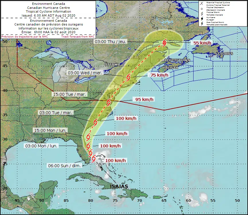
Canadian forecasters are keeping an eye on tropical storm Isaias as it churns up the U.S. Eastern Seaboard.
The storm brought heavy rain and high winds to the Bahamas and is now tracking along the coast of Florida, where it could dump up to 150 millimetres of rain.
Andy Firth, a meteorologist with Environment Canada, says the storm is expected to approach the Maritimes by mid-week.
“At this point in time, it’s way too early to speculate on the intensity as it moves into eastern Canada and exactly where,” said Firth on Saturday.
The Canadian Hurricane Centre issued a tropical cyclone information statement from New Brunswick on Sunday morning.
It said Isaias could bring locally heavy rainfall and gusty winds to parts of the region Wednesday or Thursday.
In its 6 a.m. AT Sunday update, the Canadian Hurricane Centre said the system is expected to be a tropical storm or post-tropical depression by the time it reaches the Maritimes.
The “cone of uncertainty” or probable track of Isaias ranges from southern New Brunswick to the Gaspe Peninsula.
Firth said the storm track has been shifting further to the west over the past few days, which could be good news for us.
“Tropical systems, as they move over land, it takes some of the punch out of them. The longer it can move over land before it gets up to eastern Canada then chances are it will be a weaker system,” he said.
Even though it is too early to speculate on potential impacts, Firth encourages residents throughout the Maritimes to be prepared nonetheless.
“The message is for people just to be aware that something is moving up toward eastern Canada mid-week next week and keep an eye on forecast information that we issue,” he said.
Here are the 5 AM Sunday, August 2 Key Messages for Tropical Storm #Isaias. For more information, visit https://t.co/tW4KeFW0gB, and visit https://t.co/SiZo8ohZMN for your local forecast. pic.twitter.com/zgAa2RN574
— National Hurricane Center (@NHC_Atlantic) August 2, 2020


