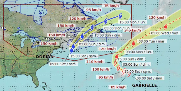
The forecasted track of Hurricane Dorian issued by the Canadian Hurricane Centre at 9 a.m. on Sept. 7, 2019. (Photo credit: Canadian Hurricane Centre)
The effects of hurricane Dorian are starting to be felt across much of the Maritimes.
The centre of the category 1 storm was located about 542 kilometres southeast of Halifax, N.S., as of 9 a.m. Saturday.
It is expected to make landfall as a category 1 storm near Halifax on Saturday evening.
“Severe winds and heavy rain are in store for parts of Atlantic Canada and eastern Quebec,” said the Canadian Hurricane Centre in a statement.
Hurricane warnings are in effect for the south shore, central and eastern Nova Scotia and western Newfoundland. Hurricane watches are in effect for eastern Prince Edward Island and the Magdalen Islands.
Tropical storm warnings are in effect for southeastern New Brunswick, Prince Edward Island, western and northern Nova Scotia, parts of northern and southwestern Newfoundland, the Magdalen Islands and parts of Quebec’s Lower North Shore.
Rainfall Impacts
The heaviest rain is expected to fall over Nova Scotia, according to Environment Canada.
Widespread amounts of 100 to 150 millimetres are expected over western regions, but some areas could receive more than 200 millimetres by the time the rain ends overnight or Sunday morning.
Central and northwestern regions of the province are forecast to receive 60 to 120 millimetres.
In New Brunswick, rainfall warnings are in place for most of the province, with the exception of Carleton, Victoria, Madawaska and Restigouche counties.
Rainfall amounts of between 50 and 100 millimetres are expected before the rain ends overnight or Sunday morning. The heaviest amounts are expected over southeastern regions.
Wind Impacts
Forecasters say Nova Scotia is also expected to receive the brunt of the winds from Dorian.
Wind gusts are expected to reach 120 kilometres per hour, but some areas along the coast could see gusts up to 150 kilometres per hour.
In New Brunswick, wind gusts are forecast to be in the range of 50 to 80 kilometres per hour.
The exception is the Moncton area, which could see wind gusts up to 90 kilometres per hour Saturday night.
“The impact of the wind will likely be increased by foliage on the trees, causing broken branches and tree falls, potentially resulting in power outages, blocked roads, and other damage,” said the New Brunswick Emergency Measures Organization in a news release Friday.
Storm Surge
Storm surge warnings are in effect for the north shore of Prince Edward Island, western Cape Breton, the Magdalen Islands, Quebec’s Lower Quebec North Shore, and Anticosti Island.
“Current guidance suggests water levels approaching inundation levels during high tide,” said the Canadian Hurricane Centre. “However, when combined with rough and pounding surf, there may be flooding and overwash of waves.”
Forecasters say waves of seven to 10 metres will reach the southwestern shore of Nova Scotia during the day Saturday and spread to the eastern shore Saturday night.
Waves of four to seven metres are expected to impact north-facing coasts of the Gulf of St. Lawrence.
“Note that waves will break higher along some of the coastlines, and dangerous rip currents are likely. Please exercise extreme caution.”


