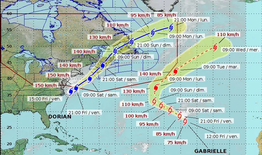
The forecasted track of Hurricane Dorian issued by the Canadian Hurricane Centre at 3 p.m. on Sept. 6, 2019. (Photo credit: Canadian Hurricane Centre)
The Canadian Hurricane Centre continues to track Hurricane Dorian as it makes its way toward the Maritimes.
Bob Robichaud, a meteorologist with the Canadian Hurricane Centre, said the centre of the storm made landfall in the Carolinas on Friday morning.
“The maximum sustained wind speeds are 150 kilometres per hour, so it’s maintained its strength over the last few hours,” said Robichaud.
Robichaud said the centre of Dorian is expected to track across eastern regions of Nova Scotia late Saturday.
But he said there is still a bit of uncertainty in terms of the exact track.
“We’re still looking at errors involving track forecasting that are about 80 kilometres,” Robichaud said, “so basically, that means given the angle of approach, a potential track anywhere from western Nova Scotia to Cape Breton is still on the table.”
🔴 #LIVE NOW on Facebook with Bob Robichaud, Warning Preparedness Meteorologist to talk about #Hurricane #Dorian https://t.co/MR9WJ7Llz4
— ECCC Canadian Hurricane Centre (@ECCC_CHC) September 6, 2019
Robichaud said the strongest winds will be in eastern Nova Scotia, where gusts could reach 150 kilometres per hour along parts of the coast.
Prince Edward Island and southeastern New Brunswick could also see wind gusts up to 90 kilometres per hour as Dorian passes through.
Forecasters say the heaviest rainfall will be to the left of the storm’s track, particularly in Nova Scotia.
“We’re expecting anywhere from 50 to 100 millimetres with potentially reaching 150 millimetres in some localized areas,” Robichaud said.
Southern and southeastern regions of New Brunswick could receive up to 90 millimetres of rain.


